
Guagus Lake
Gallery
Store

Quick Facts
| Features | lake, stream |
| Access | old road |
| Route Difficulty | easy |
| Water Body Type | lake, stream |
| Current Type | none, low |
| Route Type | loop |
| Route Distance | 7.3 km return |
| Portage Distance | 50 metres |
| Estimated Time | 4 hours |
| Elevation Change | None |
| Scenery Rating | beautiful |
| Cell Reception | none |
| Fees | none |
Description
Note: Weather conditions can drastically vary the speed and difficulty of your trip. Please plan accordingly.
As we stood on the beach at the put-in, a large beaver circled offshore. It was a gray day and a slight rain had just started. We had come all this way to paddle so we weren't deterred. We put the canoe in the water and started to paddle. The mirror like water was only interupted by the drops of rain piercing the surface. We headed along the shore on the left because in researching the lake I knew there was a large wetland along that shore.

We paddled along the wetland silently dipping our paddles into the water. We didn't want scare away any moose that may be hanging out in the wetland. We didn't see any but there were lots of tracks in and out of the wetland so they were here. Beyond the wetlands small boulders poked up out of the water. In the distance we saw the black and white heads of a couple of Hooded Mergansers. They soon flew off to find a more quiet part of the lake.
The shoreline began to widen into a wetland. We were fascinated to see yellow pond lilies poking through the shallow, muddy bottom. It was only May so they had a bit of growing to do before they reached the water's surface. We passed by a small island and the lake continued to get shallow. You could see tufts of grass growing out in the lake, which wasn't a good sign. We reached the end of the lake and saw a large raptor in a tree at the edge of the wetland. We debated on whether it was a hawk or an eagle. Once we got close enough I used my zoom lens to confirm that it was a young bald eagle. He was big but probably only about a year old since his head hadn't yet started to change to white. It must be good eating in the lake!
At the end of the lake we were provided with three choices. We continued past the first couple of large channels on the right. We would come back to them, but first we wanted to check out the smaller channel straight ahead. We soon came to a beaver dam and the channel didn't look like much beyond the dam.

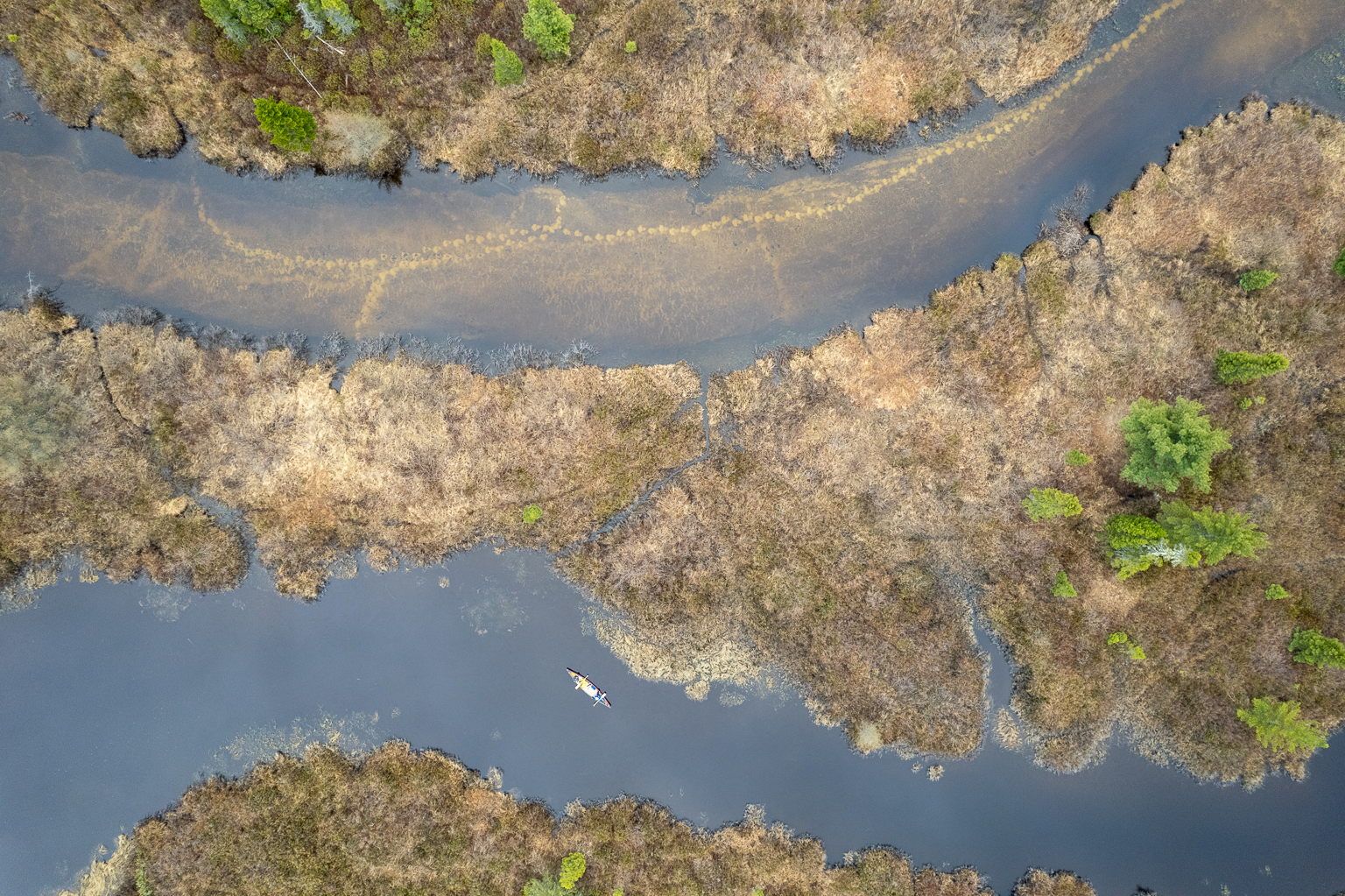
We checked out the middle channel and soon went around a turn and came to the end of it. I figured it was time to fly the drone for some recon. I got very excited when I saw clear tracks going up the third channel. A moose may be close so I put the drone away and we headed for the third channel. There was a slight current indicating that this was the main inlet stream
At the mouth the inlet stream, we watched a couple of Greater Yellowlegs fish in the shallows. After getting lots of photos and video of the two fascinating little birds we continued up stream. We soon came to the place where I saw the tracks. They were made from the white sand on the stream bottom being stirred up and over the dark leaves and other plants that covered the bottom. We may not have even noticed them if it wasn't for the drone flight. The bad news was that they didn't look fresh.
We stopped for lunch at a bend in the stream and then continued up the stream. The stream was narrow and deep, and meandered up through the wetland. We came to a bend in the river where the trees were narrowing in. We could have went further but decided to turn around. Every time I saw signs of a moose I thought I would have to come back sometime and just sit here and wait.
When we exited the stream we continued back along the other side of the lake. This side of the lake was much rockier. There were large boulders along the shore and others just under the surface of the water. We eventually came around a point and could see the camp near the put-in. It was still a calm day so we decided to head straight for the large white pine tree next to the put-in.
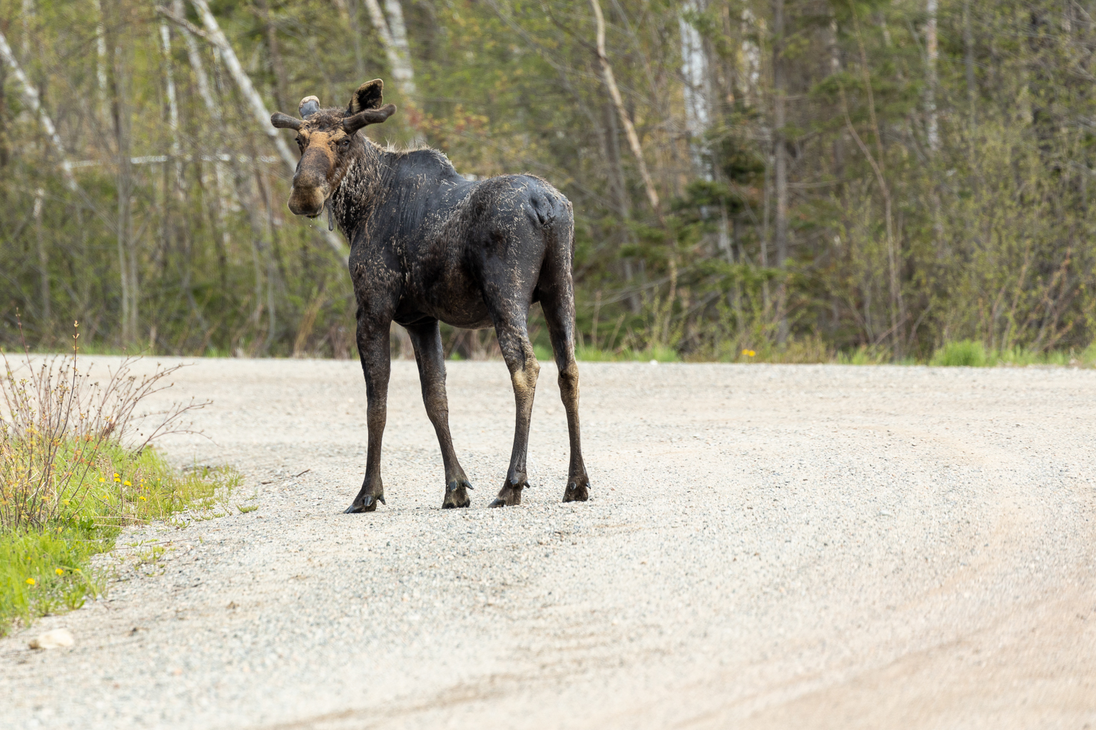
After loading the canoe on the car we started our drive home. I got dad to drive so I could get out and take pictures if anything crossed the road. Soon after we started driving a cow moose crossed the road. We had got our moose! We were even more excited when we drove a bit further and came across a young bull standing in the road. He stood there for quite a while I got the shot. A great way to end a great day in the woods with my dad.
Map
Directions
Guagus Lake is deep in the woods to the west of the City of Miramichi. It is accessed through gravel forestry roads. They are main haul roads for forestry operations so use caution, especially if you are there during the week.
Head west on route 425 to Sunny Corner. At Sunny Corner turn right across from the Irving onto Northwest Road. After 2 kilometres turn left onto Back Road. Cross the river, climb a hill (1.4 km) and then turn right onto Mullin Stream Road. At 2 kilometres you will drive past two large steel drums (loadliners) that are used to straighten up loads of logs. Just past the loadliners the pavement ends. Just after the pavement ends turn left onto Mullin Stream Road. It is another 40 kilometres on gravel road to get to the lake.

At around 20 kilometres you will drive through an s-turn that crosses a bridge over Mullin Stream. Fun Fact: I helped build this bridge as a summer job during University. Just past the S-turn you will come to a split in the road. At the split stay left. This is also the way to get to Mullin Stream Falls. A beautiful waterfall and great place to swim.
Drive for another 13 kilometres and you will come to another split in the road. Turning right will take you to Mullin Stream Lake. You need to keep straight to get to Guagus Lake. The road is a bit rougher from here. Drive for another 6 kilometres and you will pass a camp and cross a bridge. Just past the bridge (100 metres) you will find an old road on the right. Park in the first of this road. On foot follow the old road for 100 metres to a bench and large pine tree beside the shore of Guagus Lake.
Other Routes nearby
Trail Last Hiked: May 20, 2023.
Page Last Updated: November 18, 2023.